
Resources for Local Communities and Governments
 Local Waterfront
Revitalization Program
Designated Waterways
Laws & Regulations
Consistency Decisions
Public Notices
Frequently Asked Questions
Contact Us
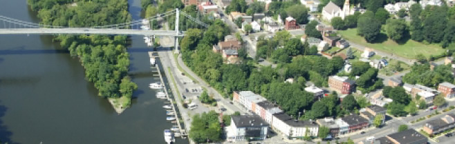
The City of Kingston Local Waterfront Revitalization Program is a locally prepared comprehensive land and water use plan for the City's natural, public, and developed waterfront resources along the Hudson River and Rondout Creek.
The City of Kingston LWRP refines and supplements the State's Coastal Management Program and provides a comprehensive framework within which critical waterfront issues can be addressed and planned waterfront improvement projects can be pursued and implemented. The approval history of City of Kingston LWRP was published in a final public notice.
The highlighted text is a download link for the fulll City of Kingston LWRP document.
The links below provide easy access to each part of the City of Kingston LWRP, as approved in 1992:
Executive Summary
Section I. Waterfront Revitalization Boundary
Section II. Inventory and Analysis
Section III. Local Policies and Applicable State Policies
Section IV. Proposed Land and Water Uses and Proposed Projects
Section V. Techniques for Local Implementation of the Program
Section VI. State and Federal Actions and Programs Likely to Affect Implementation
Section VII. Consultation with Other Affected Federal, State, Regional, and Local Agencies
Section VIII. Local Commitment
Appendix AA. Coastal Fish and Wildlife Habitat Rating Form, Narrative, and Maps
Appendix A - Proposed Land Use Map
Appendix B - Kingston Zoning Map
Appendix C - Navigational Channels Map
The City of Kingston is making great strides in revitalizing East and West Strand along its Rondout Creek waterfront with projects to enhance the appearance of the Sewage Treatment Plant façade, and develop strategies to mitigate flooding in the area.