
Resources for Local Communities and Governments
 Local Waterfront
Revitalization Program
Designated Waterways
Laws & Regulations
Consistency Decisions
Public Notices
Frequently Asked Questions
Contact Us
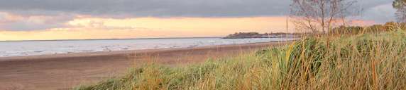
The Town of Hamburg Local Waterfront Revitalization Program is a locally prepared comprehensive land and water use plan for the Town's natural, public, and developed waterfront resources along Lake Erie and the Eighteen Mile Creek.
The Town of Hamburg LWRP refines and supplements the State's Coastal Management Program and provides a comprehensive framework within which critical waterfront issues can be addressed, and planned waterfront improvement projects can be pursued and implemented.The Town's LWRP was originally approved in 1989, and subsequently amended in 2012 to better reflect current conditions and issues. The approval history of the Hamburg LWRP was published in a final public notice.
The highlighted text is a download link for the fulll Town of Hamburg LWRP document.
The links below provide easy access to each part of the Town of Hamburg LWRP, as amended and approved in 2012:
Introduction
Section I. Local Waterfront Revitalization Area Boundary
Section II. Inventory and Analysis of Existing Conditions
Section III. Local Waterfront Revitalization Program Policies
Section IV. Proposed Land and Water Uses and Proposed Projects
Section V. Techniques for Local Implementation
Section VI. State and Federal Actions and Programs Likely to Affect Implementation
Section VII. Local Commitment and Consultation
Appendix A. Waterfront Consistency Review Law and Waterfront Assessment Form
Appendix B. Zoning
Appendix C. State Designated Significant Coastal Fish and Wildlife Habitats
Appendix D. Aerial Photographs of the Shoreline
Appendix E. Guidelines for Notification and Review
Map Gallery
The 1989 Town of Hamburg LWRP provides a historic perspective on the evolution of the Town’s waterfront revitalization efforts along Erie Lake and Eighteen Mile Creek.
The Town of Hamburg, in collaboration with the Department of Transportation (DOT), is advancing the construction of a Route 5 gateway entrance to the waterfront neighborhoods along Lake Erie. The Town is also working with the U. S. Army Corps of Engineers and DOT on the design of shoreline protection improvements to an existing concrete seawall and the adjacent portion of Route 5 within Athol Springs Hamlet.