
Resources for Local Communities and Governments
 Local Waterfront
Revitalization Program
Designated Waterways
Laws & Regulations
Consistency Decisions
Public Notices
Frequently Asked Questions
Contact Us
The Village of Sleepy Hollow Local Waterfront Revitalization Program is a locally prepared comprehensive land and water use plan for the Village's natural, public, and developed waterfront resources along the Hudson River.
The Village of Sleepy Hollow LWRP refines and supplements the State's Coastal Management Program and provides a comprehensive framework within which critical waterfront issues can be addressed, and planned waterfront improvement projects can be pursued and implemented. The approval history of Village of Sleepy Hollow LWRP was published in a final public notice.
The highlighted text is a download link for the full Village of Sleepy Hollow LWRP document.
The links below provide easy access to each part of the Village of Sleepy Hollow LWRP, as approved in 1997:
Executive Summary
Section I. Local Waterfront Revitalization Area Boundary
Section II. Inventory and Analysis
Section III. Local Policies and Applicable State Policies
Section IV. Proposed Land and Water Uses and Proposed Projects
Section V. Techniques for Local Implementation of the Program
Section VI. State and Federal Actions and Programs Likely to Affect Implementation
Appendix A. Proposed Haverstraw/Tappen Zee Scenic Area of Statewide Significance
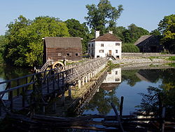
The Village of Sleepy Hollow concentrates its waterfront improvement efforts on restoring riverfront facilities along Hudson River, which will create space for educational exhibits on river ecology and house comfort stations for hikers using the River Walk and Horseman's Trail. For this reason, the Village also conducted architectural and feasibility studies and developed design drawings for adaptive re-use of the Kingsland Point Park bath house.