
Resources for Local Communities and Governments
 Local Waterfront
Revitalization Program
Designated Waterways
Laws & Regulations
Consistency Decisions
Public Notices
Frequently Asked Questions
Contact Us
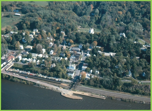
The Town of Rhinebeck Local Waterfront Revitalization Program is a locally prepared comprehensive land and water use plan for the Town's natural, public, and developed waterfront resources along the Hudson River.
The Town of Rhinebeck LWRP refines and supplements the State's Coastal Management Program and provides a comprehensive framework within which critical waterfront issues can be addressed, and planned waterfront improvement projects can be pursued and implemented. The approval history of Town of Rhinebeck LWRP was published in a final public notice.
The highlighted text is a download link for the full Town of Rhinebeck LWRP document.
The links below provide easy access to each part of the Town of Rhinebeck LWRP, as approved in 2007:
Section I. Waterfront Revitalization Boundary
Section II. Inventory and Analysis
Section III. Local Policies and Applicable State Policies
Section IV. Proposed Land and Water Uses and Proposed Projects
Section V. Techniques for Local Implementation of the Program
Section VI. State and Federal Actions and Programs Likely to Affect Implementation
Section VII. Local Commitment and Consultation
Appendix A. Scenic Areas of Statewide Significance (SASS)
Appendix B. New York State Coastal Fish and Wildlife Habitats
Appendix C. Town of Rhinebeck Waterfront Consistency Review Law
Appendix D. Town of Rhinebeck Historic Buildings Protection Law
Appendix E. NYS Freshwater Wetlands Map
Appendix F. Guidelines for Notification and Review
Map Gallery
The Town of Rhinebeck uses its LWRP to guide the development of a Greenway Trail system, to enhance public access to the Hudson River, and assist in protecting its designated historic and scenic districts.